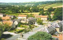
View of the village, looking NW from the church tower (64K high-resolution image).
| The village of Gilling East is situated at the western end of Ryedale in the North Riding of Yorkshire (now in North Yorkshire under the new boundaries created in 1974). It is included in the old Saxon wapontake of Ryedale. The name of the village, Gilling East, is purely a Post Office appellation, to define it and to avoid confusion with the village of Gilling West in Richmondshire, 40 miles away from Gilling East. More confusion exists because there is also a Gilling West wapontake and a Gilling East wapontake. The Gilling East wapontake does not include the village of Gilling East but covers an area near Northallerton. |
View of the village, looking NW from the church tower (64K high-resolution image). |
Geologically the village lies at the eastern end of the Gilling-Coxwold Gap, partly on the northern slope of the Howardian Hills and partly on the flat plain of Ryedale. It has a naturally commanding position dominating the east-west passage from Ryedale to the Vale of Mowbray. The Gap here is about one and a half miles wide; and also a north-south passage through the Howardian Hills to York. This latter pass is now traversed by the B1363. This road via its connection through Oswaldkirk and Helmsley provides an alternative route to the A19 to Teesside. It is not surprising therefore that the site has been occupied from early times, certainly during the Saxon and Norman eras. It early developed as a fortified site. The bluff to the south-west of the village, rising steeply some 140ft above the level of the plain, has been fortified by the presence of Gilling Castle definitely since Norman times, and perhaps even earlier. There is no evidence of a building previous to the castle of the D’Etton’s, but the land around it has been so severely altered by levelling in order to provide playing fields for the school that all evidence has probably been destroyed.
The village site is well watered. The main stream in this part of Ryedale is the Holbeck, which flows from west to east to enter the Rye about 3 kilometres east of East Ness. There is also a small stream called locally the Little Holbeck which empties the Fairfax Lakes and enters the Holbeck near Gilling Bridge. A third stream, the Howl Beck, rises above Grimston Manor and flows north through the village, to meet the Holbeck a few yards downstream from where the Little Holbeck joins the main stream. This latter stream runs the full length of the village main street on the west side of the road. It is fed by numerous springs below Grimston Manor and by one in particular, most conveniently sited opposite the church in the centre of the village. This spring (left; Feb. 2000) gushes out of the hillside and provides a very copious and reliable source of clean water, no matter what the state of the weather. After rain it seems to take time before the flow of water increases. This spring was no doubt the village water supply. I know of no wells in the village at all (though I understand that a well exists in the old estate house now known as “The Cottage” in Cawton Road). This fact, combined with the strategic position of the castle site, was no doubt the reason for the existence of the village in the first instance. Unless these streams are cared for and kept clean the land at the junction of the three streams floods. Hence the old, original village stopped at the Fairfax Arms Inn, and it was not until the railway came that any attempt was made to extend the village beyond the cross-roads. The east-west road from Cawton to Redcar Farm clings to the higher land on the south side of the valley, demonstrating the need to keep away from the floodable low land.
![[Gilling circa 1900]](../c1900.gif)
A postcard of the village taken between 1895 (when the railway footbridge was built) and 1906 (when the signal box was moved). Click here for a high-resolution image (163K).